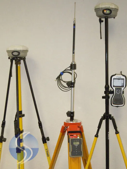
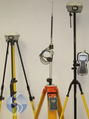

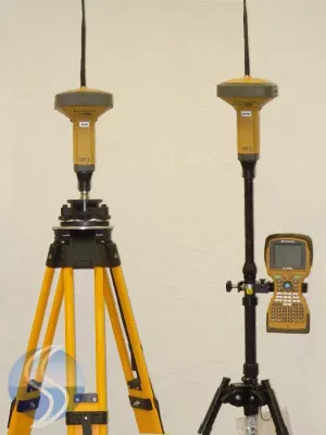
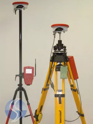
Trimble R8 Model 3 RTK GNSS GPS Base Rover sale with TSC3 Roading Module ACCESS, lightly used year 2011, low hours. Fully serviced and calibrated by Trimble authorized, ready to working order and works flawlessly with Trimble working standards
Comes complete with radio, Antenna, Extension Pole kit and cables to power base R8 Model 3 and digital radio For Survey layout/stakeout/collection. latest GNSS Firmware
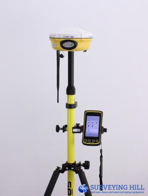
This complete R8 Model 3 GNSS RTK includes everything and ready to work;
- 2x Trimble R8 Model 3 Rover and Base GNSS RTK system with internal radio 450 to 470Mhz
- 4x Trimble New Receiver Batteries
- 1x Trimble TSC3 field controller include Roading Module with ACCESS Software
- 1x Trimble TDL-450H External Radio
- 1x USB Download Cable
- 1x Trimble dual Charger
- 1x Hard Shell Case
- Cradle holder
- All required Cables
- Carbon Fiber Rover Rod
- Crain Bi-pod
- Radio Antenna Tripod
- Trimble 2 Meter Fixed Tripod
The Trimble R8 Model 3 GNSS Receiver sets the new standard for full-featured GNSS (Global Navigation Satellite System) receiver technology. This integrated system delivers unmatched power, accuracy and performance in a rugged, compact unit.
Loaded with 220 channels receiver with base and rover functionality, able to track GPS L1 / L2, L2C, L5 and GLONASS signals, also aability to track the Galileo constellation (optional upgrade). It featured ”R-Track Signal Prediction” which greatly improved the receiver’s performance around canopy and other sky obstructions (for short bursts of time). Where the Trimble R8 Model 2 would maintain a fixed solution at the outer extents of a tree’s foliage, the Trimble R8 Model 3 enabled you to take shots under light to medium canopy. CMRx was a new protocol that was necessary for the receiver to compress and transmit the data that was now being tracked on those 220 channels. 57 MB of internal memory was upgraded for storing GNSS observations (post processing). Finally – the internal UHF radio transmit option was now a standard feature.
Trimble R8 Model 3 GNSS System Highlights:
- 220 Channels L1/L2/L2C/L5/WAAS/EGNOS/SBAS
- GPS + GLONASS + Galileo*
- 57 MB internal memory
- Base and rover operation
- Internal radio transmit
KEY FEATURES
- Advanced Trimble R-Track technology
- Unmatched GNSS tracking performance
- Includes Trimble Maxwell 6 chip with 220 channels
- Remote configuration and access
- Base and rover communications options to suit any application
Advanced Trimble R-Track Technology
The Trimble R8 GNSS delivers the latest advancements in R-Track technology, designed to deliver reliable, precise positioning performance. In challenging areas for GNSS surveying, such as tree cover or limited sky view, Trimble R-Track provides unmatched tracking performance of GNSS satellite signals.
Trimble R-Track with Signal Prediction compensates for intermittent or marginal RTK correction signals, enabling extended precision operation after an RTK signal is interrupted.
The new CMRx communications protocol provides unprecedented correction compression for optimized bandwidth and full utilization all of the satellites in view, giving you the most reliable positioning performance.
Featuring the Trimble Maxwell6 chip, the Trimble R8 GNSS advances the industry with more memory and more GNSS channels. Trimble delivers business confidence with a
sound GNSS investment for today and into the future.
Broad GNSS support
The Trimble R8 GNSS supports a wide range of satellite signals, including GPS L2C and L5 and GLONASS L1/L2 signals. In addition, Trimble is committed to the next generation of modernized GNSS configurations by providing Galileo-compatible products available for customers well in advance of Galileo system availability. In support of this plan, the new Trimble R8 GNSS is capable of tracking the experimental GIOVE-A and GIOVE-B test satellites for signal evaluation and test purposes .
Flexible System Design
The Trimble R8 GNSS receiver combines the most comprehensive feature set into an integrated and flexible system for demanding surveying applications. The Trimble R8 GNSS includes a built-in transmit/receive UHF radio enabling ultimate flexibility for rover orbase operation. As a base station, the internal NTRIP caster provides you with customized access to base station corrections via the internet.
Trimble’s exclusive, Web UI eliminates travel requirements for routine monitoring of base station receivers. Now you can assess the health and status of base receivers and perform remote configurations from the office . Likewise, you can download postprocessing data through Web UI and save additional trips out to the field
Enabling the connnected site
Pair the speed and accuracy of the Trimble R8 GNSS receiver with flexibility and collaboration tools of Trimble Access software. Trimble Access brings field and office teams closer by enabling data sharing and collaboration in a secure, web-based environment. With optional streamlined workflows, Trimble Access further empowers surveyors and survey teams for success. Now it is easier than ever to realize the potential of the Trimble Connected Site. Connecting the right tools, techniques, services and relationships enables surveying businesses to achieve more every day
TRIMBLE R8 Model 3 GNNS SYSTEM TECHNICAL SPECIFICATIONS
PERFORMANCE SPECIFICATIONS
Measurements
- Trimble R-Track technology
- Advanced Trimble Maxwell 6 Custom Survey GNSS chip with220 channels
- High precision multiple correlator for GNSS pseudorange measurements
- Unfiltered, unsmoothed pseudorange measurements data for low noise, low multipath error, low time domain correlation and high dynamic response
- Very low noise GNSS carrier phase measurements with <1 mm precision in a 1 Hz bandwidth
- Signal-to-Noise ratios reported in dB-Hz
- Proven Trimble low elevation tracking technology
- Satellite signals tracked simultaneously:
- GPS: L1C/A, L2C, L2E (Trimble method for tracking L2P), L5
- GLONASS: L1C/A, L1P, L2C/A (GLONASS M only), L2P
- SBAS: L1C/A, L5
- Galileo GIOVE-A and GIOVE-B
POSITIONING PERFORMANCE1
Code differential GNSS positioning
- Horizontal ................................................ 0.25 m + 1 ppm RMS
- Vertical ................................................... 0.50 m + 1 ppm RMS
- SBAS differential positioning accuracy2 .............typically <5 m 3DRMS
Static GNSS surveying
High-Precision Static
- Horizontal ............................................... 3 mm + 0.1 ppm RMS
- Vertical ................................................ 3.5 mm + 0.4 ppm RMS
Static and Fast Static
- Horizontal ............................................... 3 mm + 0.5 ppm RMS
- Vertical .................................................. 5 mm + 0.5 ppm RMS
Real Time Kinematic surveying3
Single Baseline <30 km
- Horizontal ................................................8 mm + 1 ppm RMS
- Vertical ................................................... 15 mm + 1 ppm RMS
Network RTK
- Horizontal ............................................... 8 mm + 0.5 ppm RMS
- Vertical ................................................. 15 mm + 0.5 ppm RMS
- Initialization time4 ........................................typically <8 seconds
- Initialization reliability4 .....................................typically >99.9%
HARDWARE
Physical
- Dimensions (W×H) ......................... 19 cm × 11.2 cm (7.5 in x 4.4 in), including connectors
- Weight ............. 1.34 kg (2.95 lb) with internal battery, internal radio, standard UHF antenna. 3.67 kg (8.09 lb) entire RTK rover including batteries, range pole, ACU controller and bracket
Temperature 5
- Operating . . . . . . . . . . . . . . . . . . . . –40 °C to +65 °C (–40 °F to +149 °F)
- Storage . . . . . . . . . . . . . . . . . . . . . . –40 °C to +75 °C (–40 °F to +167 °F)
- Humidity . . . . . . . . . . . . . . . . . . . . . . . . . . . . . . . . . . . . . 100%, condensing
- Waterproof . . . . . . . . . . . . IPX7 for submersion to depth of 1 m (3.28 ft)
- Shock and vibration . . . . . . . . . . . . . . . . . Tested and meets the following environmental standards:
- Shock . . . Non-operating: Designed to survive a 2 m (6.6 ft) pole drop onto concrete. Operating: to 40 G, 10 msec, sawtooth
- Vibration . . . . . . . . . . . . . . . . . . . . . . . . . . . . MIL-STD-810F, FIG.514.5C-1
Electrical
- Power 11 to 28 V DC external power input with over-voltage protection on Port 1 (7-pin Lemo)
- Rechargeable, removable 7.4 V, 2.0 Ah Lithium-Ion battery in internal battery compartment. Power consumption is <2.5 W, in RTK mode with internal radio. Operating times on internal battery:
- 450 MHz receive only 5.5 hours, varies with temperature
- 450 MHz receive/transmit 3.5 hours, varies with temperature and wireless data rate
- GSM 3.8 hours, varies with temperature
- Certification Class B Part 15, 22, 24 FCC certification, 850/1900 MHz.
- Class 10 GSM module. CE Mark approval, and C-tick approval
Communications and Data Storage
- 3-wire serial (7-pin Lemo) on Port 1. Full RS-232 serial on Port 2 (Dsub 9 pin)
- Fully Integrated, fully sealed internal 450 MHz receiver/transmitter option:
- Transmit power: 0.5 W
- Range6 : 3–5 km typical / 10 km optimal
- Fully Integrated, fully sealed internal GSM option 7
- Fully integrated, fully sealed 2.4 GHz communications port (Bluetooth) 7
- External GSM, Cellphone and CDPD modem support for RTK and VRS operations
- Data storage on 6 MB internal memory: 165 hours of raw observables based on recording data from 6 satellites at 15 second intervals
- Data storage on controller with 128 MB memory: Over 3400 hours of raw observables based on recording data from 6 satellites at 15 second intervals
- 1 Hz, 2 Hz, 5 Hz, and 10 Hz positioning
- CMRII, CMR+, RTCM 2.1, RTCM 2.3, RTCM 3.0 Input and Output
- 14 NMEA outputs. GSOF and RT17 outputs. Supports BINEX and smoothed carrier
1 The availability of L2C code is dependent on the US Government.
2 Accuracy and reliability may be subject to anomalies such as multipath, obstructions, satellite geometry,
and atmospheric conditions. Always follow recommended survey practices.
3 Depends on WAAS/EGNOS system performance.
4 May be affected by atmospheric conditions, signal multipath, and satellite geometry. Initialization
reliability is continuously monitored to ensure highest quality.
5 Receiver will operate normally to –40 °C, Bluetooth module and internal batteries are rated to –20 °C.
6 Varies with terrain and operating conditions.
7 Bluetooth and GSM type approvals are country specific. Contact your local Trimble office or
representative for more information