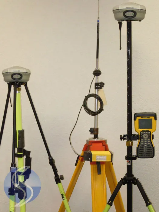

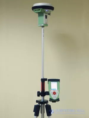
Used condition Trimble R8 Model 2 Base and Rover GNSS RTK SYSTEM with TSC2 Survey Controller, Manufacture date 2009, has calibrated and Ready to work, Glonass Activated, excellent condition.
Comes complete with radio, Antenna, Extension Pole kit and cables to power base R8 Model 2 and HPB450 External radio
This complete R8 Model 2 GNSS RTK includes everything and ready to work;
- 2x Trimble R8 Model 2 Rover and Base GNSS RTK system with internal radio 450 to 470Mhz
- 4x Trimble New Receiver Batteries
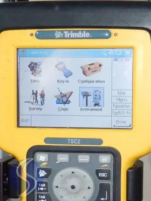
- 1x Trimble TSC2 field controller with Survey Controller instaled
- 1x Trimble HPB450 35 watt External Radio
- 1x USB Download Cable
- 1x Trimble dual Charger
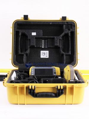
- 2x Hard Shell Case
- Cradle holder
- All required Cables
- Carbon Fiber Rover Rod
- Crain Bi-pod
- Radio Antenna Tripod
- Trimble 2 Meter Fixed Tripod
Trimble R8 Model 2 GNNS System provide 72 Channels
The Trimble R8 Model 2 provide 72 channels for satellite tracking and support, and to log raw GPS observables to the handheld controller for postprocessed applications.
- GPS L1 C/A Code, L2C, L1/L2/L5 Full Cycle Carrier
- GLONASS L1 C/A Code, L1 P Code, L2 P Code, L1/L2 Full Cycle Carrier
- SBAS WAAS/EGNOS support
Key Features
- Trimble R-Track technology for GNSS support
- Advanced receiver technology and proven system design combined
- Wireless technologies for flexibility and cable-free convenience
- Base and rover communication options to suit any application
- An important component of the Connected Survey Site model
The Trimble R8 GNSS System is a multi-channel, multi-frequency GNSS (Global Navigation Satellite System) receiver, antenna, and data-link radio combined in one compact unit. The Trimble R8 combines advanced receiver technology and a proven system design to provide maximum accuracy and productivity.
TRIMBLE R-TRACK TECHNOLOGY FOR COMPREHENSIVE GNSS SUPPORT
Powered by an enhanced RTK engine, Trimble R-Track technology supports both the modernized GPS L2C and L5 signals and GLONASS L1/L2 signals. The GNSS signals are capable of providing surveying professionals with real field benefits. With the world’s GNSS’s in constant development, surveying businesses small and large can be confident that investment in a Trimble GNSS system is protected1. Trimble, already proven in GPS technology, will continue to lead the industry in GNSS support
PROVEN SYSTEM DESIGN
From the powerful Trimble field software to the receiver itself, the Trimble R8 GNSS system’s overall design has been tried, tested, and proven. As a rover it is rugged, lightweight and cable free for unsurpassed ergonomics in the field. As a base it is flexible and also cable free: use the Trimble R8 as a base or rover according to each job’s needs
The Trimble R8 GNSS system’s flexible communication options include:
- An internal 450 MHz radio option for use as a cable-free base station
n internal GSM/GPRS option for Internet connectivity and use as a rover in a Trimble VRS™ network
Simply choose the Trimble R8 model that best suits your needs.
THE ORIGINAL INTEGRATED SURVEYING SOLUTION AND BEYOND
The Trimble R8 GNSS system is designed to support Trimble’s original Integrated Surveying solution. Combine your GPS and optical data in one job file in powerful Trimble field software such as Trimble Survey Controller. Transfer the job file seamlessly to your Trimble office software for processing.
The Trimble R8 can also be used as part of a Trimble IS Rover. Simply add a prism to the rover pole and partner the Trimble R8 with a robotic optical system such as the Trimble® S6 Total Station. This integrated solution enables you to maximize the best of both surveying techniques for even greater efficiency in the field.
Whenever you’re facing a new surveying challenge, your partnership with Trimble places the right tools and techniques, including GNSS technology, at your fingertips. Each Trimble system seamlessly integrates via shared workflows and technologies, making your everyday job site a place where the whole is greater than the sum of its parts: Welcome to the Connected Survey Site.
TRIMBLE R8 Model 2 GNNS SYSTEM TECHNICAL SPECIFICATIONS
PERFORMANCE SPECIFICATIONS
Measurements
- Trimble R-Track technology
- Advanced Trimble MaxwellTM Custom Survey GNSS Chip
- High precision multiple correlator for GNSS pseudorange measurements
- Unfiltered, unsmoothed pseudorange measurements data for low noise, low multipath error, low time domain correlation and high dynamic response
- Very low noise GNSS carrier phase measurements with <1 mm precision in a 1 Hz bandwidth
- Signal-to-Noise ratios reported in dB-Hz
- Proven Trimble low elevation tracking technology
- 72 Channels:
- GPS L1 C/A Code, L2C, L1/L2/L5 Full Cycle Carrier
- GLONASS L1 C/A Code, L1 P Code, L2 P Code, L1/L2 Full Cycle Carrier
- SBAS WAAS/EGNOS support1
Code differential GPS positioning2
- Horizontal ±0.25 m + 1 ppm RMS
- Vertical ±0.50 m + 1 ppm RMS
- WAAS differential positioning accuracy3 typically <5 m 3DRMS
Static and FastStatic GPS surveying2
- Horizontal ±5 mm + 0.5 ppm RMS
- Vertical ±5 mm + 1 ppm RMS
Kinematic surveying2
- Horizontal ±10 mm + 1 ppm RMS
- Vertical ±20 mm + 1 ppm RMS
- Initialization time typically <10 seconds
- Initialization reliability4 typically >99.9%
HARDWARE
Physical
- Dimensions (W×H) . . . . . . . . . . . . . . . . . 19 cm × 11.2 cm (7.5 in x 4.4 in), including connectors
- Weight . . . . . . . 1.35 kg (2.97 lb) with internal battery, internal radio, standard UHF antenna. 3.71 kg (8.18 lb) entire RTK rover including batteries, range pole, controller and bracket
Temperature5
- Operating . . . . . . . . . . . . . . . . . –40 °C to +65 °C (–40 °F to +149 °F)
- Storage . . . . . . . . . . . . . . . . . –40 °C to +75 °C (–40 °F to +167 °F)
Humidity . . . . . . . . . . . . . . . . . 100%, condensing
Waterproof . . . . . . . . . . . . . . . . . IPX7 for submersion to depth of 1 m (3.28 ft)
Shock and vibration .................................... Tested and meets the following environmental standards:
- Shock ................. Non-operating: Designed to survive a 2 m (6.6 ft) pole drop onto concrete. Operating: to 40 G, 10 msec, sawtooth
- Vibration . . . . . . . . . . . . . . . . . . . . . . . . . . . . MIL-STD-810F, FIG.514.5C-1
Electrical
- Power 11 to 28 V DC external power input with over-voltage protection on Port 1 (7-pin Lemo)
- Rechargeable, removable 7.4 V, 2.0 Ah Lithium-Ion battery in internal battery compartment. Power consumption is <2.5 W, in RTK mode with internal radio. Operating times on internal battery:
- 450 MHz receive only 5.5 hours, varies with temperature
- 450 MHz receive/transmit 3.5 hours, varies with temperature and wireless data rate
- GSM 3.8 hours, varies with temperature
- Certification Class B Part 15, 22, 24 FCC certification, 850/1900 MHz.
- Class 10 GSM module. CE Mark approval, and C-tick approval
Communications and Data Storage
- 3-wire serial (7-pin Lemo) on Port 1. Full RS-232 serial on Port 2 (Dsub 9 pin)
- Fully Integrated, fully sealed internal 450 MHz receiver/transmitter option:
- Transmit power: 0.5 W
- Range6 : 3–5 km typical / 10 km optimal
- Fully Integrated, fully sealed internal GSM option 7
- Fully integrated, fully sealed 2.4 GHz communications port (Bluetooth) 7
- External GSM, Cellphone and CDPD modem support for RTK and VRS operations
- Data storage on 6 MB internal memory: 165 hours of raw observables based on recording data from 6 satellites at 15 second intervals
- Data storage on controller with 128 MB memory: Over 3400 hours of raw observables based on recording data from 6 satellites at 15 second intervals
- 1 Hz, 2 Hz, 5 Hz, and 10 Hz positioning
- CMRII, CMR+, RTCM 2.1, RTCM 2.3, RTCM 3.0 Input and Output
- 14 NMEA outputs. GSOF and RT17 outputs. Supports BINEX and smoothed carrier
1 The availability of L2C code is dependent on the US Government.
2 Accuracy and reliability may be subject to anomalies such as multipath, obstructions, satellite geometry,
and atmospheric conditions. Always follow recommended survey practices.
3 Depends on WAAS/EGNOS system performance.
4 May be affected by atmospheric conditions, signal multipath, and satellite geometry. Initialization
reliability is continuously monitored to ensure highest quality.
5 Receiver will operate normally to –40 °C, Bluetooth module and internal batteries are rated to –20 °C.
6 Varies with terrain and operating conditions.
7 Bluetooth and GSM type approvals are country specific. Contact your local Trimble office or
representative for more information