
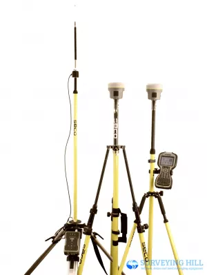
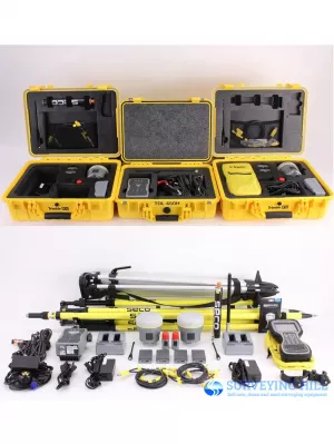
For sale Trimble R10 RTK Base Rover with Trimble TSC3 Access software, Trimble TDL-450H Radio. Everything still in excellent working condition with minor wear. The system will service and calibrated by authorized Trimble for firmware update and set up ready to working condition.
This sale complete set includes:
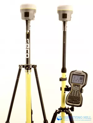
- 2x Trimble R10 Base Rover Receivers, 450-470 MHz Internal Rx/Tx Radio (403-473 MHz Option), L2, L2C, L5, GLONASS, Galileo, QZSS, & BeiDou Sats Enabled
- 2x Trimble Dual Battery Chargers
- 4x Lithium Ion Batteries
- 2x Radio Antennas
- 2x Quick Disconnect Adapters
- 2x USB Data Cables
- 1x Seco 0.25m Extension Rod
- 1x 12V Power Cable w/ Alligator Clips
- 2x Trimble Transport Cases
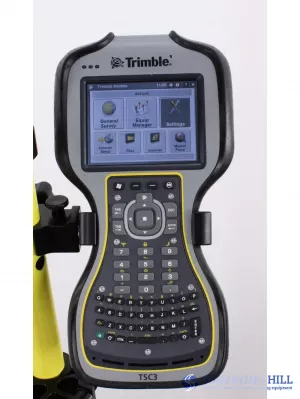
Trimble TSC3 Data Collector with Trimble Access V. 2017.21 Software, Cortex-A8 8 AM37x Processor, WLAN, WAN, Bluetooth, GPS Installed
- 1x TSC3 Rod Bracket
- 1x Touch Screen with Stylus
- 1x Pack of Screen Protectors
- 1x USB Data Cable
- 1x 120v Wall Charger
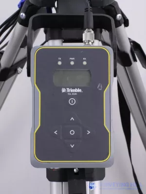
Trimble TDL 450H External Radio, 450-470 MHz Internal Radio, Programmable from 2 W to 35 W
- 1x External Antenna Kit
- 1x Data Adapter Cable
- 1x 12V Power Supply w/ Alligator Clips
- 1x Trimble Transport Case
* New Seco Fixed Tripod, New Seco Snap-Loc Rover Rod, New Seco Bipod, New Seco Radio Antenna Tripod and New Seco Snap-Loc Antenna Pole
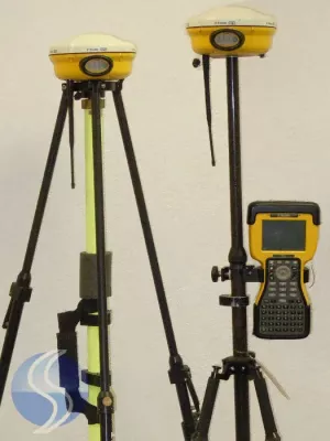
Trimble R10 GNSS System
Trimble R10 combines powerful features and groundbreaking technologies including Trimble HD-GNSS, Trimble SurePoint, Trimble 360, and Trimble xFill to provide surveyors increased productivity. User-friendly features such as a quick-release adaptor and the ability to configure the receiver from a smart phone make it easy to deploy and use as a base station or rover.
The new state-of-the-art Trimble HD-GNSS processing engine integrated in the Trimble R10 is a new generation of core positioning technology. Trimble HD-GNSS surpasses traditional fixed/float techniques to provide a more accurate assessment of error estimates than traditional GNSS processing engines. Measurements collected with Trimble HD-GNSS are precision-based so surveyors can confidently collect data in challenging environments where they may have been unable to collect data before. Reduced convergence times and instantaneous point measurements allow surveyors to start measuring sooner and up to 60 percent faster.
Supporting 440 channels with two built-in Trimble Maxwell 6 chips, the Trimble R10's integrated Trimble 360 technology allows consistent and reliable tracking of available GNSS satellite signals for existing and currently planned GNSS constellations and augmentations.
Smarter, More Powerful Technology that Simplifies the Survey Workflow
Trimble has extended its Trimble SurePoint technology, a cornerstone of the successful S-Series total stations, to the new GNSS surveying system. The incorporation of this technology simplifies the survey data collection workflow by providing faster measurements, increased accuracy and greater quality control. The Trimble R10 includes an electronic bubble that appears on the controller display so that all measurement information is displayed in one place. Trimble SurePoint constantly monitors the pole tilt and protects surveyors from collecting erroneous data by only allowing data to be stored when the survey pole is plumb. Simultaneously, pole tilt angle values are stored for every point collected to ensure data traceability.
Powered by Trimble RTX technology, new Trimble xFill leverages a worldwide network of Trimble GNSS reference stations to deliver position information via geostationary satellites. xFill seamlessly 'fills in' for RTK or VRS corrections in the event of a temporary connection outage such as a radio black spot so users experience less downtime in the field.
Compact, Lightweight and Easy-to-Use
As the smallest and lightest integrated receiver in its class, the Trimble R10 incorporates a more stable center of mass at the top of the range pole along with a sleeker, taller profile to provide surveyors with effortless handling and operation. This compact design combined with a quick release adaptor provides surveyors with an easy to use, more ergonomically balanced GNSS surveying system. Designed for ease of use and durability, the Trimble R10 offers the ruggedness and reliability for which Trimble is known.
Additional features of the new GNSS system include multiple connectivity capabilities such as Wi-Fi and 3G cellular connectivity, a lithium-ion battery, an integrated GNSS antenna, 4 GB internal memory and an internal 2 Watt radio.
In the Field - Trimble Access Software
Trimble Access is a field solution that enables wireless connectivity between the project team members to expedite data collection, processing, analysis, and project information delivery through improved workflows, collaboration and control. The complete solution speeds both typical and specialized surveying tasks, and enables easy and fast two-way information sharing between the field survey crew and the office. Surveys can be completed faster with less time spent traveling back and forth to the office. Management and field crews can closely collaborate by viewing the same information in near real-time.
Trimble Access version 2012.20 offers new functionality compatible with the Trimble R10, including:
- Tilt auto-measure: Topo point or Rapid point measurements can now be automatically started when the pole is plumbed to within a predefined tilt tolerance. Coupled with auto store, hundreds of points can be measured with only one tap on Measure.
- Tilt warnings: Users are now notified if the pole moves outside a predefined tilt tolerance during point measurement.
- Tilt distances: Measurements collected with the Trimble R10 can now have an associated tilt distance providing additional quality control information. Use the QC Graph for a quick visual check to see the range of tilt distance errors for any particular job.
- eBubble display: An electronic bubble can be used instead of a traditional pole bubble. The eBubble enables a clearer, easier and more accessible display of the bubble providing the surveyor just one place to focus when leveling and measuring.
In the Office - Trimble Business Center
Trimble Business Center office software is a complete surveying office suite designed to manage, analyze and process all field survey data, including data from optical instruments (total stations and levels), GPS/GNSS and spatial stations (imaging and 3D scanning data). Advances the capabilities of surveying offices with key new functionality, including:
- Trimble R10 support: Users can import RTK and PPK tilt magnitude and quality data from a Trimble Access Job or JobXML file and also export this data using the Custom Exporter. The new version also has the capability to Import Trimble Access Job or Job XML files containing xFill observations.
- Ribbon menu layout: A new ribbon menu layout and quick access toolbar help users quickly locate commands required to complete a task for an improved user experience.
- Microsoft Windows® 8 support: Version 2.80 is compatible with the Microsoft Windows 8 Operating System.
- Station View field-of-vision indicator: Users can view which Station Views are open and in which direction they are facing. The indicators improve workflows for measuring points photogrammetrically with images from Trimble VISION instruments.